billw6560
Member
- Messages
- 14
- Reaction score
- 14
First of all, this is not a complaint, but just my observations on the limited options available for medium range models. Living in Central Florida, we have two boating options, the Inter Coastal Waterway (ICW) just off the Atlantic in the New Smyrna Beach area, or the St Johns River. St Johns is about 200 miles long stretching from just north of Orlando up to Jacksonville, connecting to the Atlantic (ICW). We choose the fresh water St. Johns. It's a moderately wide river, about 300-500 feet in our immediate area, increasing as you go north. It's general depth varies greatly from about 10 to 30 feet or more in the main channel, and as little as 2-3 feet in some tributaries (feeder rivers/streams).
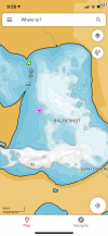
With that being said, to maximize the enjoyment of our boat, I really didn't want to play it safe and stay the the middle of the river, but really want to explore these side tributaries. The map below shows just s small portion of our section of the river, with all those wonderful spots to explore. Lots of nooks and crannies.
.jpg")
So, while you'll agree that pontoon boats in general have a relatively shallow draft, it's still a good idea to have some level of confidence that where you're getting yourself into, you can get out just as easily without running afoul of some minor obstacles like the bottom, tree limbs, hard obstructions, etc. So, at first, I thought that the Garmin Striker 4 might be an option, showing the depth from the transom, and the relative bottom contour. Of course, other than running a program like Navionics on my tablet, I have no live charting to go by.

At first glance, this seems like a possibility. However, doing the ubiquitous and required Google search, I found that the Striker 4 has multiple mounting scenarios for my model series. In the Design Center view, it shows a nicely placed Striker right in the middle of the console, flanked with the "required" analog gauges. Note the Gotcha #1 statement in red. Upon further investigation, I later found that on my original model, the Striker 4 would be mounted on the lower part of the console's right side, way out of view. It would be hard to navigate these shallow streams, constantly looking (and squinting) down at the display, taking my eyes off the water, especially given the very small 3.5" display.
So, ok, that's not going to work. I then thought of the much more viable option. The Garmin 742 or Simrad Go7 multi-function 7" displays.

So, I checked out the videos of both the Garmin and Simrad 7" display units. They were entertaining, but not very informative with regard to the actual installation. I then proceeded down to our local marine super store to check them out. My first impression was that while both units seemed capable in their own respects, the size was just not quite big enough to display for my tired eyes, and just doesn't have the charting detail I wanted. Note the Gotcha #2 statement in red. Additionally, especially given that I LOOSE all the analog gauges, I really didn't want to entirely rely on these singular displays. As an aside, while I actually like the Simrad's display options a little better (as of the 2020 model year), the display itself was grainier (not as clear) as the Garmin. I also looked at the 9" displays just for S&G's, and the Garmin was even better while the Simrad's resolution "appeared" to be the same resolution as the 7", but just using larger display pixels. I don't know if this is still the case in its current form.
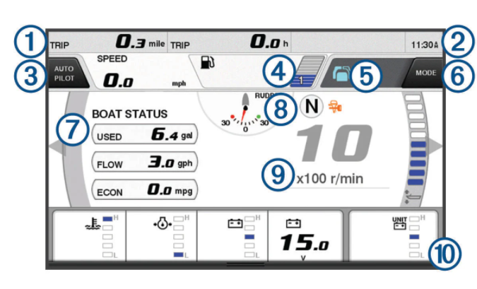
Now, as a retired Automotive Test Engineer, I'm accustomed to designing custom test systems to fit specific requirements. Undeterred, I opted to go with the Garmin 9" 942xs display, while still retaining all the analog gauges. The BIG problem, how to mount it. I went through multiple scenarios, and as seen below, I finally went with a NavPod specifically cut for the 942xs, mounted on the right side of the console using various Ram Mounts. I had originally wanted to mount the Garmin in the top center of the console, but there just isn't a way to mount it, short of removing the mini-windshield.

Now for me, the right side position is perfect, giving me good sightlines ahead while giving me a direct view of the Garmin's display at a glance. One of the biggest advantages to the Garmin, is the ability to read my Yamaha F90B engines data via the NMEA 2000 buss. While I'm getting valuable data for things like Fuel Flow (to give me data to determine optimal fuel efficiency, cruise speed, etc.), unfortunately, I'm not seeing other data like oil pressure, temperature, etc. If anyone has a solution to this, please let me know.
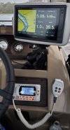
And not settling for just the 942xs, I went all the way and added a Standard Horizon GX1800 VHF radio to round out my pontoon "yacht" setup. See the final larger image below that shows the installation in more detail. While the ACC switch appears to be obscured (lower right) by the Ram Mount, it's still accessible. If desired, I can provide part numbers and a brief outline of how all these units were mounted and wired. I also have the radio tied to the Garmin's NMEA 0183 GPS position data output so that the radio can use the Automated Distress Messaging capabilities of the radio.
To summarize, while this may seem overkill to some, it would be if you were on a deep water lake or river with few obstructions. For me, having the capability of "seeing" what the bottom contour is, has saved my bacon, not to mention, my prop and toons. The only thing I would consider changing (upgrading), is a forward looking (and very expensive) sonar transducer. But that's for another day. The only other thing I may have done differently, would be to use a black NavPod (and radio). Unfortunately, when I bought it, the black model was out of stock everywhere.
As for the Bennington options issue, yes, I don't have one of those QX rockets, along with their price tag, that supports the 9" displays, etc. nav options. For me, my 20LLG is a wonderful boat which I/we intend to enjoy for many years to come. Finally, I want to give props to Bennington's tech/sales department, who were a great help in pointing me in the right direction, and providing me technical information to help me with the installation.
I hope my experiences here have inspired and informed. Thanks for looking, Bill.


With that being said, to maximize the enjoyment of our boat, I really didn't want to play it safe and stay the the middle of the river, but really want to explore these side tributaries. The map below shows just s small portion of our section of the river, with all those wonderful spots to explore. Lots of nooks and crannies.
So, while you'll agree that pontoon boats in general have a relatively shallow draft, it's still a good idea to have some level of confidence that where you're getting yourself into, you can get out just as easily without running afoul of some minor obstacles like the bottom, tree limbs, hard obstructions, etc. So, at first, I thought that the Garmin Striker 4 might be an option, showing the depth from the transom, and the relative bottom contour. Of course, other than running a program like Navionics on my tablet, I have no live charting to go by.
At first glance, this seems like a possibility. However, doing the ubiquitous and required Google search, I found that the Striker 4 has multiple mounting scenarios for my model series. In the Design Center view, it shows a nicely placed Striker right in the middle of the console, flanked with the "required" analog gauges. Note the Gotcha #1 statement in red. Upon further investigation, I later found that on my original model, the Striker 4 would be mounted on the lower part of the console's right side, way out of view. It would be hard to navigate these shallow streams, constantly looking (and squinting) down at the display, taking my eyes off the water, especially given the very small 3.5" display.
So, ok, that's not going to work. I then thought of the much more viable option. The Garmin 742 or Simrad Go7 multi-function 7" displays.
So, I checked out the videos of both the Garmin and Simrad 7" display units. They were entertaining, but not very informative with regard to the actual installation. I then proceeded down to our local marine super store to check them out. My first impression was that while both units seemed capable in their own respects, the size was just not quite big enough to display for my tired eyes, and just doesn't have the charting detail I wanted. Note the Gotcha #2 statement in red. Additionally, especially given that I LOOSE all the analog gauges, I really didn't want to entirely rely on these singular displays. As an aside, while I actually like the Simrad's display options a little better (as of the 2020 model year), the display itself was grainier (not as clear) as the Garmin. I also looked at the 9" displays just for S&G's, and the Garmin was even better while the Simrad's resolution "appeared" to be the same resolution as the 7", but just using larger display pixels. I don't know if this is still the case in its current form.
Now, as a retired Automotive Test Engineer, I'm accustomed to designing custom test systems to fit specific requirements. Undeterred, I opted to go with the Garmin 9" 942xs display, while still retaining all the analog gauges. The BIG problem, how to mount it. I went through multiple scenarios, and as seen below, I finally went with a NavPod specifically cut for the 942xs, mounted on the right side of the console using various Ram Mounts. I had originally wanted to mount the Garmin in the top center of the console, but there just isn't a way to mount it, short of removing the mini-windshield.
Now for me, the right side position is perfect, giving me good sightlines ahead while giving me a direct view of the Garmin's display at a glance. One of the biggest advantages to the Garmin, is the ability to read my Yamaha F90B engines data via the NMEA 2000 buss. While I'm getting valuable data for things like Fuel Flow (to give me data to determine optimal fuel efficiency, cruise speed, etc.), unfortunately, I'm not seeing other data like oil pressure, temperature, etc. If anyone has a solution to this, please let me know.
And not settling for just the 942xs, I went all the way and added a Standard Horizon GX1800 VHF radio to round out my pontoon "yacht" setup. See the final larger image below that shows the installation in more detail. While the ACC switch appears to be obscured (lower right) by the Ram Mount, it's still accessible. If desired, I can provide part numbers and a brief outline of how all these units were mounted and wired. I also have the radio tied to the Garmin's NMEA 0183 GPS position data output so that the radio can use the Automated Distress Messaging capabilities of the radio.
To summarize, while this may seem overkill to some, it would be if you were on a deep water lake or river with few obstructions. For me, having the capability of "seeing" what the bottom contour is, has saved my bacon, not to mention, my prop and toons. The only thing I would consider changing (upgrading), is a forward looking (and very expensive) sonar transducer. But that's for another day. The only other thing I may have done differently, would be to use a black NavPod (and radio). Unfortunately, when I bought it, the black model was out of stock everywhere.
As for the Bennington options issue, yes, I don't have one of those QX rockets, along with their price tag, that supports the 9" displays, etc. nav options. For me, my 20LLG is a wonderful boat which I/we intend to enjoy for many years to come. Finally, I want to give props to Bennington's tech/sales department, who were a great help in pointing me in the right direction, and providing me technical information to help me with the installation.
I hope my experiences here have inspired and informed. Thanks for looking, Bill.
Attachments
Last edited: