FIRE UP
Well-Known Member
- Messages
- 172
- Reaction score
- 352
Hey gang,
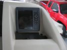
I don't know of this question or questions should be posted in this section of the forum but, I couldn't find where else to ask. We have a 2014 Bennington 25RCL with the Yamaha 350HP 5.3L. We purchased this boat approximately 3.5 years ago and it's been a flawless operating boat. Installed in the dash on the right side is Garmin Echo Map 50s. I'm not a real wizard when it comes to operating and changing things on it. I just use it as it came. We live in Lake Havasu City AZ and the lake is the primary area we operate that boat in. For the almost 4 years of use/owning/operating this boat, and using that Garmin, it's been working just great. I normally pick one of the *Combination* screens to use for my day trips. Any one of the three available work. Normally, when I finally get the boat out and we're starting to float or motor around some, I turn on the Garmin and pick one of the combinations.
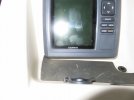
The screen will typically show the shore line, various coves, and edge contours etc. Well, here in lies my recent problem. I turn it on now and there is NO SHORE LINE, no coves, no visible tracks that I've already made up and down the lake into any coves etc. They are ALL GONE! No tracks and no shore line. I changed to charts and still the same, no shore line and coves etc. Hmmmmm. The screen is primarily blue-gray. We (my son and I) have zoomed in, out, and all that and there's still no showing of any shore line etc.
In the almost 4 years of ownership of the boat AND this Garmin unit, I have never "updated" it. I have updated the Garmin Zumo XT I use on my motorcycles and the Garmin Travel version I used in our motorhome. But, I've never updated this unit. Never even thought about it. As stated, this Garmin unit has been functioning flawless every time I use it. Each time we go out for a day ride, when I turn it on, It will show the many tracks, up and down the lake and into and out of coves, our Thompson bay and even where the Colorado river enters our lake. But, NO TRACKS, NO SHORE LINE! Can someone direct me to where I need to go to get help on this? I'd sure appreciate it.
Scott
I don't know of this question or questions should be posted in this section of the forum but, I couldn't find where else to ask. We have a 2014 Bennington 25RCL with the Yamaha 350HP 5.3L. We purchased this boat approximately 3.5 years ago and it's been a flawless operating boat. Installed in the dash on the right side is Garmin Echo Map 50s. I'm not a real wizard when it comes to operating and changing things on it. I just use it as it came. We live in Lake Havasu City AZ and the lake is the primary area we operate that boat in. For the almost 4 years of use/owning/operating this boat, and using that Garmin, it's been working just great. I normally pick one of the *Combination* screens to use for my day trips. Any one of the three available work. Normally, when I finally get the boat out and we're starting to float or motor around some, I turn on the Garmin and pick one of the combinations.
The screen will typically show the shore line, various coves, and edge contours etc. Well, here in lies my recent problem. I turn it on now and there is NO SHORE LINE, no coves, no visible tracks that I've already made up and down the lake into any coves etc. They are ALL GONE! No tracks and no shore line. I changed to charts and still the same, no shore line and coves etc. Hmmmmm. The screen is primarily blue-gray. We (my son and I) have zoomed in, out, and all that and there's still no showing of any shore line etc.
In the almost 4 years of ownership of the boat AND this Garmin unit, I have never "updated" it. I have updated the Garmin Zumo XT I use on my motorcycles and the Garmin Travel version I used in our motorhome. But, I've never updated this unit. Never even thought about it. As stated, this Garmin unit has been functioning flawless every time I use it. Each time we go out for a day ride, when I turn it on, It will show the many tracks, up and down the lake and into and out of coves, our Thompson bay and even where the Colorado river enters our lake. But, NO TRACKS, NO SHORE LINE! Can someone direct me to where I need to go to get help on this? I'd sure appreciate it.
Scott